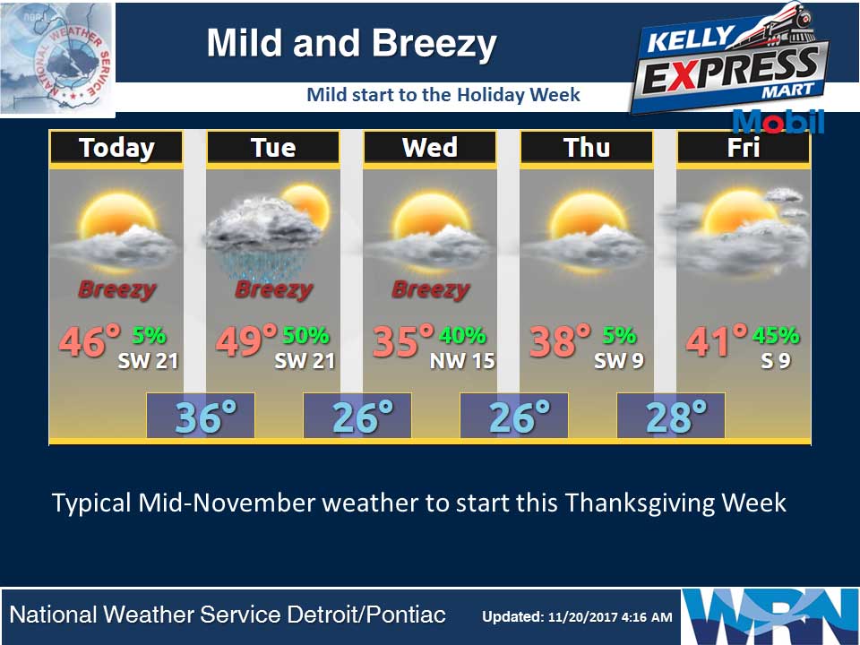
A relatively quiet period is expected into mid week as no major weather system are forecast to affect the area. We may see a bit of light rain on Tuesday along and ahead of a cold frontal passage. In its wake Tuesday afternoon into Wednesday morning a bit of lake effect snow will occur. Little to no snow accumulation is expected however. We will see highs both today and on Tuesday in the 40s. Temperatures will tumble again behind the Tuesday cold front with high on Wednesday only forecast to reach the 30s. The Thanksgiving outlooks is for good travel weather across Lower Michigan with dry weather and high temperatures around 40.
Today
Sunny. Highs in the mid 40s. Southwest winds 10 to 20 mph with gusts to around 30 mph.
Tonight
Mostly clear. Lows in the mid 30s. Southwest winds 15 to 20 mph.
Tuesday
Mostly cloudy. A 50 percent chance of rain showers in the afternoon. Highs in the mid 40s. Southwest winds 15 to 20 mph becoming west in the afternoon. Gusts up to 30 mph.
Tuesday Night
Partly cloudy. Lows in the mid 20s. Northwest winds 10 to 15 mph. Gusts up to 25 mph in the evening.
Wednesday
Mostly sunny. Highs in the mid 30s. Northwest winds 5 to 10 mph.
Wednesday Night
Partly cloudy. Lows in the mid 20s.
Thanksgiving Day
Mostly sunny. Highs in the upper 30s.
Thursday Night
Partly cloudy. Lows in the upper 20s.
Average high temperature for today is 46. Average low temperature is 31.
The high temperature in Jackson yesterday was 38 at 1:42 AM, the low was 27 at 9:33 PM.
0.01 inches of precipitation yesterday. Total precipitation for the month to date: 4.41 inches.
Sunrise today at 7:35 AM EST. Sunset at 5:12 PM EST.